Global Geography Library

Global Geography Library (GGL) is a comprehensive platform designed to provide academic libraries, corporate customers, institutions, and other knowledge centers with access to a vast collection of atlases, maps, charts, and related resources. It excels at providing geographic content at an affordable price point, while also enabling seamless search and integration with other technologies.

Global Geography Library features several different content types, including:

  • Atlases
  • Earth Sciences
  • Thematic, Reference, Commercial, Educational
  • Maritime
  • Terrain Analysis Reports
  • Topographic

Read on below for available GGL collections and more features and benefits of GGL, including custom projects with GGL+.
Featured Collection

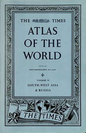
Times Comprehensive Atlas of the World Digital Archive

Empower your library patrons, researchers, or institution with access to the complete digital archive of The Times Comprehensive Atlas of the World.

First published in 1895, The Times Comprehensive Atlas of the World is renowned for charting geopolitical and geographical shifts in an ever-changing world. This collection provides users with an unparalleled view of the world’s most prestigious and authoritative world atlas.

  • Includes 45 atlases – comprising 16 Comprehensive and three Pre-Comprehensive editions
  • High Quality Viewing: The digital atlases faithfully represent the physical originals, with accurate colors and high resolution for a true-to-life viewing experience
  • Robust Searching: Effortlessly search all atlases to quickly find place names, countries, keywords, and other terms across the entire collection

GGL Collections

Contact Us for more information or to request a trial.

GGL: Atlases
Collection Name Item Count Published
The Times Comprehensive Atlas of the World 45 1895-2023


GGL: Earth Sciences
Collection Name Series/Scale Item Count Published
Greece 1:50,000 326 1956-2015
Israel 1:250,000 2 2021
Mozambique 1:250,000 78 2006-2007
Zambia 1:100,000 265 1960s-2016


GGL: Maritime
Collection Name Series/Scale Item Count Published
Israel scales vary 12 2009-2023
Cuba BSB Charts scales vary 226 2010s-2024


GGL: Terrain Analysis Reports

Collections include 1:200,000 topographic maps, reports (in Russian and English), and soil diagrams.

Collection Name Series/Scale Item Count Published
Afghanistan 1:200,000 512 1960s-1990s
China 1:200,000 6,409 1960s-1990s
Jordan 1:200,000 104 1960s-1990s
North Korea 1:200,000 141 1960s-1990s
Syria & Lebanon 1:200,000 47 1960s-1990s
Ukraine 1:200,000 617 1960s-1990s


GGL: Thematic, Reference, Commercial, Educational
Collection Name Series/Scale Item Count Published
Freytag & Berndt: Africa varies 19 2009-2023
Gitashenasi (Iran) varies 439 1975-2023
Ukraine Cartographic Group varies 120 2008-2024
Israel varies 14 2014-2023


GGL: Topographic
Collection Name Series/Scale Item Count Published
Israel City Maps (Hebrew) 1,645 2023
Israel 1:25,000 (Hebrew) 97 2023
Israel 1:50,000 (Hebrew) 28 2024
Israel 1:50,000 (English) 28 2020-2023
Israel 1:100,000 (Hebrew) 22 2019
Karta Mira (“Maps of the World”) 1:2,500,000 262 1946-1980
Madagascar 1:50,000 162 1955-1988
Madagascar 1:100,000 405 1950-1998
Madagascar 1:500,000 11 1985-1992
Malawi 1:50,000 153 1962-1996
Myanmar (EV Map) 1:50,000 1,148 2014
Samoa (EV Map) 1:50,000 16 2020
Senegal 1:50,000 142 1955-1971
Senegal 1:200,000 27 2005-2008
Tanzania 1:250,000 64 1960-2000


GGL Features & Benefits

  • Extensive Collections: Access a diverse collection of maps, both under copyright and non-copyright, covering various geographical regions, historical and current periods, and categories.
  • Centralized Content: While some content may be widely available, this platform consolidates it in one place, simplifying access and search for users.
  • User-Friendly Interface: The intuitive interface allows users to navigate the library, access resources, and search with ease.
  • Searchable Content: The platform offers robust search capabilities, including keyword search and faceted filtering, allowing users to find exactly what they’re looking for quickly and efficiently. Where available, searching the text within the maps themselves allows for powerful and fast identification of places and features.
  • Index Map for Spatial Discovery: The platform includes an index map that aids in spatial discovery, helping users understand the geographical context of each map and how it connects to others.
  • Cross-Referencing and Related Resources: In addition to maps, users can access related documents such as reports and studies, creating a comprehensive knowledge base.
  • Seamless Mosaic of Maps: Users can view a seamless mosaic of maps, providing a complete picture of an area while maintaining proper spatial relationships among the maps.
  • Permanent URLs: Each map has a unique, permanent URL, allowing users to reference and share specific resources.
  • WMTS Integration: Where allowed, the platform provides WMTS URLs, allowing users to bring the mosaic into a Geographic Information System (GIS) environment of their choice for further analysis and exploration.
More Features:
  • IP authentication
  • Unlimited simultaneous users
  • Detailed item-level metadata
  • Usage statistics
  • PDF and Hi-res IIIF viewing
  • Citation generator
  • MARC records (upon request)

Build Your Own Collections with GGL+

GGL+ is a fully customizable platform option for customers wanting to digitize and platformize their own materials, with the option to add any of East View’s pre-built collections. GGL+ can accommodate a wide variety of materials and formats, including PDFs, high-resolution IIIF image files, and zip files. While most GGL collections are map focused, customers can host virtually any content, including data, handbooks, and other internal documents. GGL+ also accommodates multiple access models (IP authentication and/or username/password), with the ability to restrict access to certain materials for different users. Contact us to learn more.

Interested in more information?

  • All fields are required. You will receive an error message if you click "submit" with an empty field. Fill in any empty fields and re-check the "I'm not a robot" box in order to successfully submit the form. If you encounter difficulties please contact [email protected].
  • This field is for validation purposes and should be left unchanged.