National Atlas of the Arctic

An essential and comprehensive resource on the Russian Arctic region

The long-awaited National Atlas of the Arctic [Национальный атлас Арктики] is now available from East View while copies last. The culmination of years of intensive scientific research and surveying, this library-quality edition was published in 2017 by Rosreestr Roskartografiia with the assistance of the Russian Geographical Society. The monograph boasts 495 pages of maps, illustrations, and text detailing circumpolar Earth above 66° North, with a focus on all Russian Arctic territory, Arctic seas and coastlines. A complete geographical names list is included (indexed to Cyrillic alphabet order).

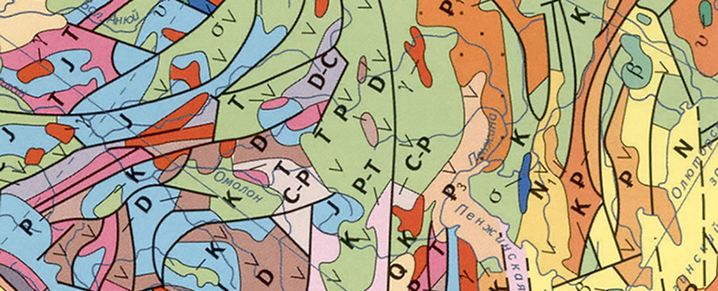
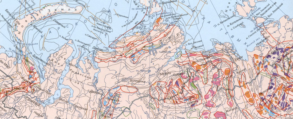
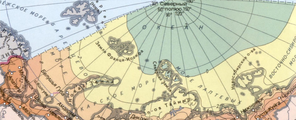
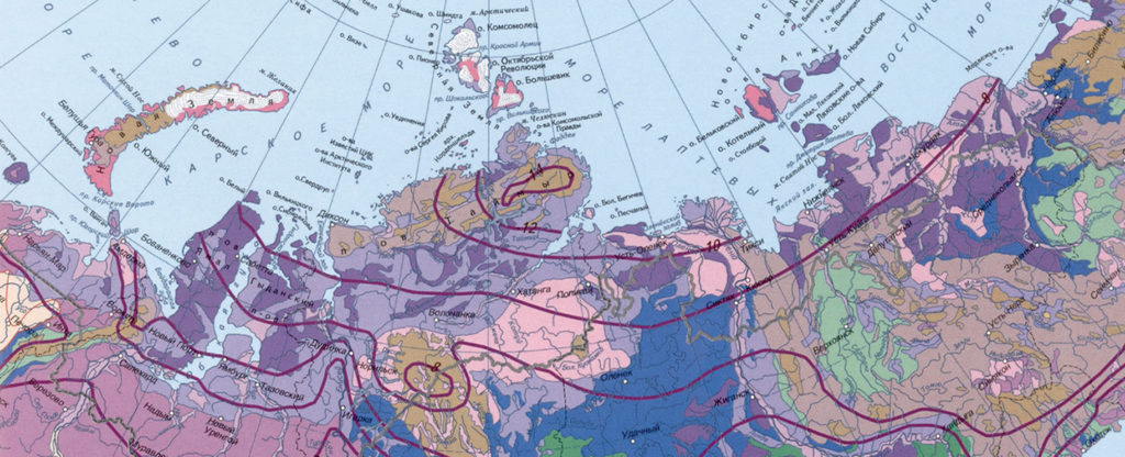
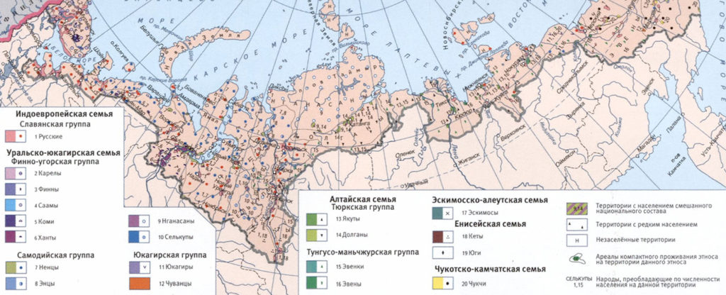
The Arctic area of the Russian Federation has never before been presented so comprehensively in a monograph of this level. Almost 500 thematic, satellite, and nautical maps in the National Atlas of the Arctic’s 22 sections feature vivid and exhaustive overviews of Arctic geography; political subdivisions; land use; and geological, climatic, glaciation and permafrost characteristics of the Arctic Ocean and the northernmost parts of the continents of Asia, Europe, and North America.

Also included are narratives on the history of surveys and marine expeditions in the Russian Arctic; its geomorphology, mineral resources, and development potential; climate, ocean, and coastal attributes; permafrost changes; topographic relief and subsoil characteristics; habitat and natural environment; indigenous populations and social structures; economic development; and an outlook to year 2020 plans by the Russian Federation for its strategic priorities in Arctic exploration, development, and monitoring via satellite.

National Atlas of the Arctic

Details

  • ISBN: 9785952303867
  • Year: 2017
  • Publisher: Rosreestr Roskartografiia
  • Language: Russian
  • Pages: 495
  • Format: Print, hardcover
  • Size: 30 x 42 cm
  • Price: $865.00

Contents

Section 1: Introduction

  • World Arctic
  • General Characteristics of the Arctic Area of the Russian Federation
  • The Federal Subjects Included in the Russian Arctic
  • History of Research, Discoveries and Development of the Arctic

Section 2: Geological Structure

Section 3: Relief

Section 4: Subsoil Resources

Section 5: Evolution of the Natural Environment

Section 6: Climate

MoreLess

Section 7: Ocean, the Sea

Section 8: Coasts of the Sea

Section 9: Snow Cover, Glaciers, Permafrost

Section 10: Land Waters

Section 11: Soil Cover

Section 12: Plant and Animal World

  • Vegetation
  • Animal World

Section 13: State of the Environment and Nature Conservation

Section 14: Population, Culture

Section 15: Cultural, Spiritual and Natural Heritage

Section 16: Economy

Section 17: Land Use

Section 18: Strategic Planning

Section 19: Ecological Safety, Natural and Technogenic Cause Risks

Section 20: Russian Arctic Areas that Have a High Anthropogenic Impact

Section 21: Arctic Exploration by Space-Based Techniques

Section 22: Arctic as an Area of International Cooperation

Featured Sections

Geological Structure

The section contains maps, texts, reference data and illustrations characterizing the geological structure of the Arctic area of the Russian Federation, including tectonics and seismotectonic activity, geodynamics and modern movements of the earth’s crust, and the state of magnetic and gravimetric fields. Maps of Quaternary formations, heat flows, geochemistry of subsoil are also included.

Subsoil Resources

The section characterizes the mineral resources of the Arctic area of the Russian Federation. The presented maps, texts, reference data and illustrations give an idea of the location of oil and gas and coal basins, oil, gas and coal deposits, metallogenic zones and belts, ore occurrences, precious metals, polymetallic ores and diamonds, etc., including on the continental shelf.

Climate

The section consists of a series of maps and explanatory texts that characterize the climatic factors, climatic conditions and resources of the Arctic area of the Russian Federation, including atmospheric circulation, heat and water regime, current and expected climate changes, and other indicators of the climate change trend.

Snow Cover, Glaciers, Permafrost

The section contains maps, texts, reference data and illustrations related to the glaciological and snow and ice processes and resources of the Arctic area of the Russian Federation. Maps and text materials contain data on the duration of the snow period, the dates of their establishment and snow cover, the current state of the ice sheet and glaciers, the distribution and characteristics of frozen rocks, their thickness, average annual temperature, ice content, etc.

Population, Culture

The information presented in this section reflects the current demographic situation, the areas of residence of indigenous small peoples (the location of national settlements, camps), and migration of the population. Plots and themes of the maps show the contrast of the development of the region: from the foci of almost primitive economy and stages of different forms of nomadism to modern urban formations.

Interested in more information?

  • This field is for validation purposes and should be left unchanged.